The Nootka Experience
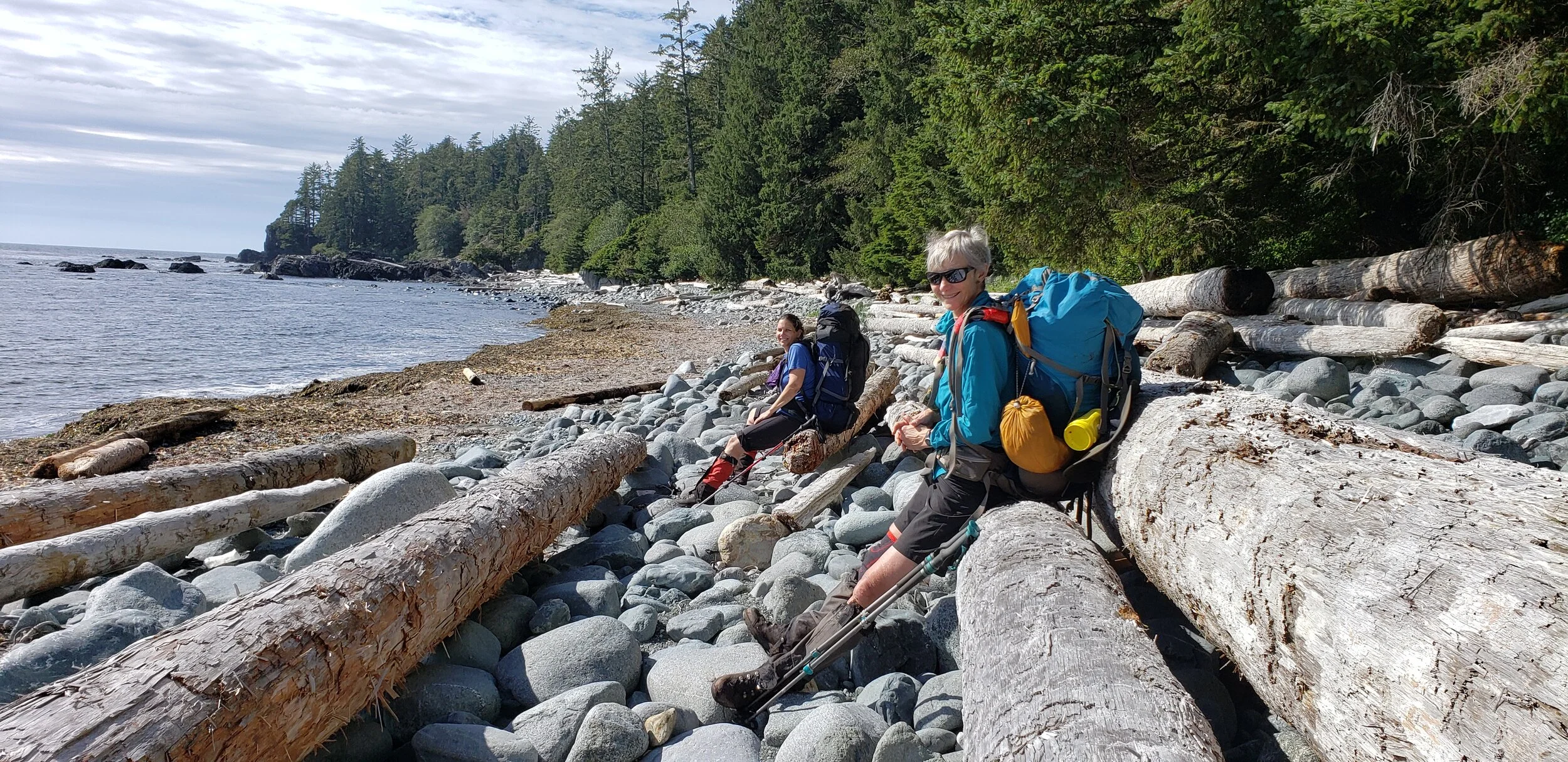
In September 2021 a small group of four backpacked from Friendly Cove to Louie Bay, on the traditional and unceded territory of Nuu-chah-nulth First Nation on Vancouver Island, taking eight days for the adventure. Here is the story of the trip from NVOC Member Alexander with images from the group.
8th - 15th September 2021 (photos are at the end)
Day 1: - Friendly Cove
Early start to get the 6:30 am ferry from Horseshoe Bay to Nanaimo. Just as well we had reservation as there were many more vehicles than I would have expected at that time of the morning. Had breakfast on board and a smooth sailing to Nanaimo. Drove from Nanaimo to Gold River (approx. 3hours). Had a quick lunch at the Float Plane dock as Air Nootka said that they could take us out earlier than our scheduled time.
Weather was not great and tides working against us, so we decided to hike from South to North. Float Plane took us to Friendly Cove (my first Float Plane ride) and landed us at the Lighthouse dock. Lighthouse keepers came down to meet us – very friendly and let us fill up fresh water. Light rain eased off but as tide was against us for the first creek-crossing we decided to camp for the day next to the church and took advantage of shelters that Native Carvers had set up.
Went for a look around and found an ATV trail and 6 cabins that looked somewhat abandoned. Some amazing old-growth trees in evidence.
Had an early evening meal – not even 5:30 pm – and an early to bed night. Is this what the future holds for us as seniors! 😊
Huge thunderstorm overnight – must have been directly overhead – so only slept fitfully.
Day 2: - Friendly Cove to Beach Camp (un-named)
Still raining when we got up, reasonably early to make first creek-crossing at low tide. Got packed up after breakfast and thankful for the shelters that kept most of the rain off the tents.
Started raining very heavily so we had to wait until it eased off. Made good time along the ATV track through the forest and made it to the creek in time to wade across without any trouble. Rain eased off and on again as we made our way along the beach but then we had to use the inland trail to get past headlands. To say that the trail is not well maintained is a bit of an understatement! Because of the rain, which did get heavier at times, the trail was almost completely under water. Boots and feet got completely soaked. Because of rain, didn’t bother with side trail to Maquinna Point or other viewpoint – probably would have been no view anyway. Trail not well marked at all through the worst swampy part, but we did manage to get through. Took 9 hours to cover an estimated 7.5 km of what was one of – if not the – toughest day’s hiking that I have done!
Stopped raining enough to let us set up camp and get a tarp up over our cooking area and get some dry clothes on. Rain cover for backpack still allowed some stuff to get a bit damp. Turned in for the night about 8:30. 60 lbs. pack took its toll on my muscles.
Day 3: Un-named to Beano Creek
An easy start to the day getting up about 8:30 am. Looked like a nice day – no rain. Saw 3 hikers coming from the North and heading to Friendly Cove to catch the plane out. As it was about 10:00 am when we saw them and as the plane pickup was for 3:30 pm, I doubt that they would make it in time – despite their youth!
Seems that there were about 25 people who had been stuck at Beano Creek because of flash floods due to the storm. Some had been held up for a day, hence the rush to get out. Wished them luck and warned about the swampy trail ahead of them. As we made our way along, we encountered others from Beano who were on their way out. Some scary stories about crossing Beano Creek.
Much of the day’s hike was on inland trails again to get around the headlands as the tides were against us once more. It seems that the inland trail is just a continual series of climbing over or crawling under fallen trees. There are also lots of ‘Brenda steps’ which makes a steady pace not the easiest to achieve. Getting up from and down to the beach often entails a steep rope-assisted climb\descent. Did make it to some sea caves but mostly in the trees again. All was going OK until we got to one creek that should have been nothing at all but because of the rain was running more than it should. Slipped on the log step and fell backwards into the creek and banged my head on an old tree that was across the creek too. Got everything soaked as backpack went in first. Had to wriggle out of it to get back up again ☹ Well, it’s only water so once I regained my composure, we started off again – lovely feeling with boots squelching and all my clothing sticking to me. Eventually reached the descent down to Beano Creek - an awesome rope descent next to a waterfall. Thanks fully the tide was just out far enough that we didn’t have to land into the waves. Before we could get to the campsite though, we had to wade across Beano Creek. It wasn’t anywhere as bad as it had been but that still didn’t prevent my right foot sinking into the soft sand\gravel just as I reached the other side. Leg collapsed and I got yet another dunking. Unfortunately, this time the camera got dunked too and potentially ruined ☹
Adding insult to injury, it started raining as we were setting up camp. Got a tarp up for the cooking area again but as I had only a dry T-Shirt and fleece had to borrow a pair of pants from Sheila. Then discovered that my tent was wet and sleeping bag was more than just a bit damp, so Sheila lent me hers. Martina bunked in with Rob and Sheila and I used Martina’s (Rick’s) one-person tent.
We had some chicken noodle soup and retired for the night. This was not my best day!
Day 4: Rest Day
Day started off a bit misty and I was up first because that one-person tent was so cramped. Wandered into the kitchen area and then noticed something about 10 yards to my left. It was a wolf looking straight at me. Went for my camera and discovered that it did get wet and was not going to work. Hoping that it will dry out. Everyone else got up and we found that there were 6 wolves on the beach. Rob and Martina did get some photos though. One wolf started howling and kept on until a 7th came back from further up the beach past our camp. Really cool to see them and they posed no threat at all.
The day eventually brightened up and I was able to get a lot of my wet stuff dried out especially when a nice breeze got up to go with the sun. Tent and sleeping bag were dry enough to use that night. Did enjoy the rest day and we saw a whale – or whales – offshore but just too far away to geta clear view. Mostly just saw it\them blow and mini breach. Again, cool to see!
Day 5: Beano Creek to Calvin Falls
Another easy start to the day and a leisurely breakfast watching whale(s) blow out at sea. Once more, a bit too far off to see clearly but still good to see, nonetheless.
As we headed out along the beach, we encountered 4 more hikers heading South. They had camped at Calvin Falls the previous night. Beach walking was easier than the inland trails, but the stench of rotting seaweed got a bit much in places. On solid rock or sand, walking was relatively easy, but the soft sand and pebbles started to tell on my right hip. I had to stop several times just to rest for a few minutes.
Highlight of the day was our encounter with bears on the beach. Saw the first one digging in the seaweed about 50 yards or so ahead of us and we were upwind from it so I guess it didn’t smell us. We stopped and got together to make ourselves look bigger and waved and banged poles. The bear did kind of look at us but carried on digging. Whilst we were deciding the best move, another bear just wandered out of the bushes about 20 yards – if that – in front of us. At first it started walking towards us although not aggressively. Much banging of poles and shouting persuaded it to amble off into the bushes again. We moved closer to the other bear and did the same, so it also ambled off into the bushes. Both looked like very big, healthy bears but they did not seem to be too interested in us.
Eventually made it to Calvin Falls, which was a really nice spot. Big beach and the waterfall coming of the rocks just before the creek goes into the ocean. Some people have been very creative with the camps that they have set up. One even had some old netting strung up as a bed\hammock with a makeshift ladder strung together to get on to it.
I was not feeling great. Got very lightheaded and lost focus so Rob and Sheila helped put my tent up and I laid down for about an hour or so. Was just going to go to bed but Sheila suggested that I should eat something. Was not feeling at all hungry but compromised and Martina gave me some miso soup. I think that I was asleep by about 6:30 pm.
Day 6: Calvin Falls to Skuna Bay
Day 6 was to be another rest day because of the time of low tide (11:30 am) we decided to have a late start and rather than just move camp across the creek, hike a short day to Skuna Bay. This would leave another short day to Sandy (First) Beach.
Can’t believe how much I slept. Must have been exhaustion from yesterday. Anyway, after another leisurely breakfast, we set off at 11:15 am and crossed Calvin Creek without issue. Made good progress along the beach and came across another 3 hikers heading South. Three women – mother, daughter and friend – who were a bit scared by bear and wolf encounters and had used a sat phone to get an early pick up – from Bajo Point apparently. We didn’t run into any more bears or wolves on our way to the next camp. The hike to Skuna Bay only took us about 2 ½ hours (including lunch and chatting to the hikers). We had been warned of rain for the evening so set up the tarps for the kitchen area just in case. As it was a nice day, got a bit more stuff dried out. Martina said she saw a wolf, but it must have gone into the woods as none of the rest of us saw it, but we did hear some howling. Another bear showed up about 2 or 3 hundred yards away up the beach from our camp just as we were preparing to go to bed.
Day 7: Skuna Bay to Sandy (First) Beach
It rained quite heavily overnight, so was glad that we had put up the tarps. There had also been a bit of a wind, so the tarps needed a bit of sorting before we could get breakfast. Light rain eventually eased and then stopped long enough for us to get packed up. A momma bear and two cubs showed up down the beach from us but had already left before we headed that way. Light rain continued to fall again so it was a full waterproofs day for me, which made for a bit of a sweaty hike! We made good time along the beach and only had 4 big creeks to cross – all of which I managed without falling into, or even getting wet, for a change! We only had one inland trail to get around a headland. We did manage to get completely turned around on that trail though as there was a bypass trail past a particularly swampy bit. What we hadn’t noticed was that there was a bypass on either side of the swamp and when we got past the swamp, we ended up going back on the bypass for the other side. Was only when I recognized a tree that I had already climbed over that we realized we were heading back the way we had come. Ended up going all the way back to the start of the inland trail to check we hadn’t missed a turn somewhere. Eventually went back to the swampy area and then noticed that the trail continuing was not as distinct as the second bypass which had looked like the well-worn path. Once we had found the correct trail again, we made it to Sandy (First) Beach and set up camp for the last time. Despite the time retracing our steps on the trail, we got to the beach with plenty of time to construct a kitchen area and put up the tarps.
Checked along the beach to find the trailhead for our hike out tomorrow – or so we thought!
Day 8: Sandy (First) Beach to Louie Bay
Got up early (6:00 am) so that we could have breakfast and strike camp in plenty of time to get to our pick-up point at Louie Bay. It had been a bit cooler overnight so there was much condensation on everything and although it was looking like being a nice day, tents and tarps were still very wet as we packed up. Got going by 9:00 am (pickup was at 11:00 am) so should have been plenty of time for the short hike to Louie Bay.
Headed off up the beach to the trailhead that we found yesterday. There was no signage or marking to indicate where the trail went\came from and as it turns out, this was the wrong trail and was going to Tongue Point (water taxi drop-off). Despite the fact that we seemed to be following the coast, we did not question whether or not it was the correct trail until we had been going for 1 ½ hours! ☹ As this was now 10:30 am, we had to use the sat. phone to call Air Nootka and let them know we would not be able to meet at 11:00 am. Air Nootka explained that they were busy, and we would need to call again when we did get to Louie Bay to see when we could get picked up. We backtracked to Sandy (First) Beach and managed to only take an hour to do that, but it then took at least 30 minutes to find the correct trail. Thank goodness it was a nice day because the trail was in a very poor state and would have been absolutely miserable if it was raining. Again, there were no markings to indicate where the trail was going.
Eventually got to Louie Bay and called Air Nootka again but we were told to call back in about 20 minutes whilst they sorted out a new pick-up time. Found out that they could not pick us up until 5:30 pm, which meant we had a 3 ½ hour wait! ☹ Not much room at Louie Bay so we just had to sit and wait it out. Although it was a nice sunny day, there was a stiff breeze blowing that made it a bit uncomfortable just sitting around. Still, we were up to it and found various ways to pass the time. Watched a sea otter in the bay, which was a pleasant distraction for a short while. It is amazing how slowly time passes when you are waiting!
Just about 5:00 pm we heard, then saw, a plane fly over but it did not seem to be coming our way. As it turned out of sight, we were surprised when it suddenly appeared over the trees above us and landed in the bay. We quickly got ourselves ready and the plane came right up to the beach. We had to hold the plane against the wind, not an easy task, whilst our gear was loaded. We were able to get on the plane without having to wade out into the bay, as we had thought would be required. As the last person on, I had to hold the plane and then push it off the beach. That was a real struggle against the wind. Hopped up onto the float but had to take of my water shoes, dry my feet and shoes before getting in – pilot said that they can’t have saltwater get inside the plane. The plane took off without issue and the pilot took us over the route of the trail that we had hiked. Saw the remains of the wreck out by Tongue Point and, as we flew down the coast, saw a whale below us. The pilot did a very quick banking – which caught Martina by surprise – to see if we could get a better look, but the whale had dived so it was only a fleeting glance that we got.
Eventually landed back at the Air Nootka dock about 6:00 pm. Any idea of our planned lunch at the Gold River Golf Club was a definite non-starter so we aimed to get to Nanaimo for the 10:00 pm ferry. Given that it is about a 3-hour drive, we were not going to be stopping for gas or to eat. Dropped Martina off in Courtney at her daughter’s new house, then headed on to Nanaimo and got to the ferry terminal with plenty of time to spare 😊
The ferry was due to sail at 10:10 pm but we didn’t start loading until just gone 10:20pm. As there were not a lot of vehicles, loading didn’t take long. Got served in the cafeteria quickly – well except for Rob as they obviously had to first catch, then cook, his salmon! 😊 – and had an uneventful sailing, getting into Horseshoe Bay shortly before midnight. Got home just after midnight. This was a challenging, but epic, adventure! 😊
Text by Alexander